Satellite data shows the significant decline in air pollution with Nitrogen dioxide (NO2) in the Netherlands following impressive air quality improvement across the Europe.
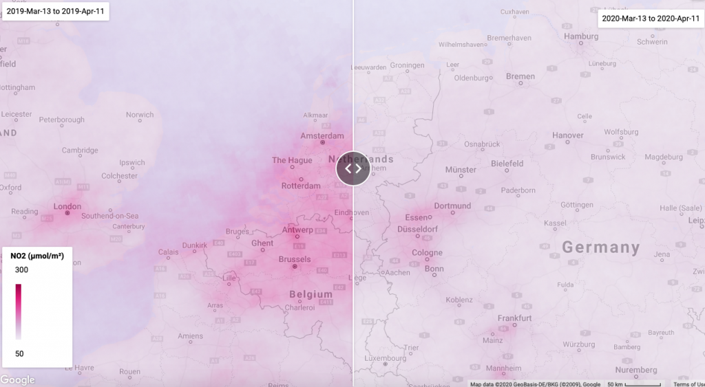
The corona virus pandemic is having a major impact on air pollution over the Netherlands with national lockdown, and indeed the air quality has been significantly improved since March 2020. New Satellite data from Sentinel-5P reveals a sharp decline in Nitrogen dioxide (NO2) concentrations over the Netherlands and European countries.
Nitrogen dioxide (NO2), primarily emitted from burning fossil fuels for transportation and electricity generation (industry), can be used as an indicator of changes in human activity.
We processed Sentinel-5P satellite data in Google Earth Engine observing the overview of NO2 changes across the Netherlands and the European countries, comparing March and April 2019 and 2020. Although there is still a lot of pollution in Europe, the improvement is still obvious enough.
The map presents a comparison of the mean NO2 emissions in the period preceding the COVID-19 outbreak and during the pandemics. The right side of the map shows the period from the beginning of the national lockdown in the Netherlands on the 13th of March 2020 to present, whereas the left map indicates for an equal period in 2019.
Data source: Sentinel-5P Near Real Time Data (European Comission/ESA/Copernicus)
You can check the App at Google Earth Engine for the rest of the world: See the link